What Exactly is Launching?
NISAR (NASA–ISRO Synthetic Aperture Radar) is a joint Earth-observation satellite developed by NASA and ISRO. It features two SAR instruments on a single platform:
-
NASA’s L-band SAR
-
ISRO’s S-band SAR
It will orbit in a Sun-synchronous, dawn-dusk orbit at ~747 km altitude, 98.4° inclination, with a 12-day repeat cycle. A 12-meter gold-mesh reflector on a 9-meter boom captures a ~242 km swath. All data from NISAR will be free and openly available.
The satellite will be launched by India using the GSLV Mk-II (GSLV-F16) with a 4-meter fairing from the Satish Dhawan Space Centre (SDSC), Sriharikota. The lift-off mass is ~2,400 kg based on ISRO’s I-3K satellite bus.
Mission Duration:
NASA outlines a baseline 3-year science mission with consumables for ~5 years. As of July 25, 2025, ISRO officially lists the mission life as 5 years, aiming for extended operations.
Workshare Details:
-
NASA: L-band radar, 12-m reflector, 9-m boom, GPS, solid-state recorder, high-rate telecom, payload data system
-
ISRO: S-band radar, spacecraft (I-3K), GSLV Mk-II launch, satellite operations
-
Both agencies will provide ground support and data distribution.
SAR Fundamentals (Static Core)
How SAR “Sees” (Active Microwave)
SAR is an active sensor: it sends microwave pulses and records echoes. It works day or night, in any weather, unlike passive optical sensors.
Synthetic Aperture: Instead of requiring a physically long antenna, SAR synthesizes one using the satellite’s motion to build high-resolution images.
Key Geometry Terms:
-
Along-track (Azimuth): Direction of satellite motion
-
Across-track (Range): Perpendicular to motion
-
Slant range vs Ground range: Important SAR image dimensions
L-band vs S-band
Penetration and Use:
-
L-band penetrates vegetation, dry soil, and snow, making it ideal for monitoring biomass, ground deformation, and ice sheets.
-
S-band interacts more with leaves and surface textures, useful for assessing crop structure, moisture, and sea-ice characteristics.
-
Dual-band SAR helps separate canopy and ground responses.
Polarimetry: NISAR supports various polarization modes (e.g., HH, HV, VH, VV). These enhance the ability to classify surfaces and estimate biomass.
Revisit and Repeat Cycles
-
Repeat cycle: 12 days (same ground track)
-
With both ascending and descending passes, average sampling = ~6 days
-
Sun-synchronous orbit ensures the satellite crosses the same area at ~6 a.m. and ~6 p.m., maintaining consistent lighting — crucial for change detection.
Interferometry (InSAR)
SAR captures the phase of radar waves. Comparing the phase from two different passes gives line-of-sight displacement — down to millimetre accuracy.
Interferograms: These visualize movement (e.g., tectonic shifts) with color fringes, each corresponding to half the radar wavelength of displacement. L-band is better for vegetated terrains due to longer wavelength and better coherence.
Orbit & Mission Profile
Coverage Cadence: Entire Earth mapped every 12 days (ascending + descending = ~6-day average revisit).
Swath & Resolution:
-
Swath: ~242 km
-
Resolution: ~3–10 m (mode-dependent); ISRO cites 5–100 m
-
Achieved via SweepSAR: Transmits over full swath and “sweeps” receiving beams for wide, high-res coverage.
What Can NISAR Measure?
Biomass & Carbon:
L-band penetrates canopy, enabling estimation of woody biomass, forest degradation, and carbon stock changes — useful for climate goals like REDD+.
Ground Deformation:
Tracks earthquakes, volcanic activity, subsidence, and landslides using InSAR — valuable for disaster risk reduction.
Cryosphere:
Monitors ice-sheet flow, glacier movement, and sea-ice — vital for understanding sea-level rise.
Coasts & Wetlands:
Maps shoreline changes, mangrove extent, storm impacts — works well even in cloudy monsoon regions.
Agriculture & Water:
Tracks crop extent, health, soil moisture, and impacts of irrigation or groundwater withdrawal.
Disaster Response:
Plans to provide data within hours during emergencies. NASA’s Alaska hub and ISRO will distribute these datasets rapidly.
ISRO–NASA Cooperation & Open Data
Both agencies follow a free and open data policy.
This policy enhances scientific use, supports operational agencies, and aligns with India’s evolving data policy.
Launch Vehicle Family: GSLV vs LVM3
The Launcher Chosen
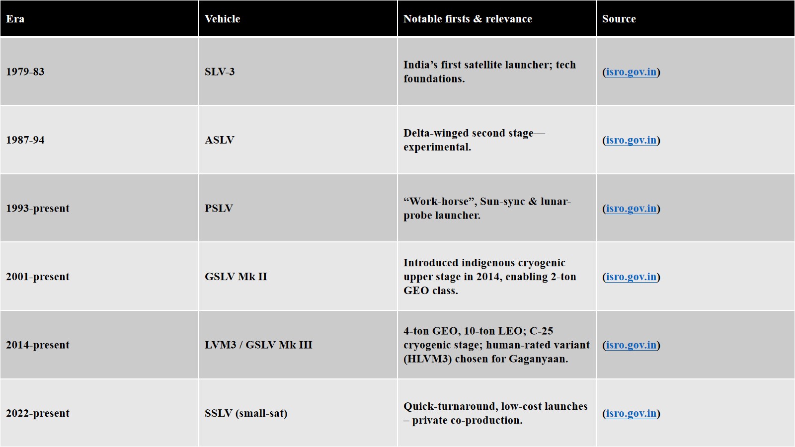
GSLV Mk-II:
-
Uses CE-7.5 cryogenic upper stage (LH₂/LOX, staged-combustion)
-
Fairing options: 3.4 m (metallic), 4.0 m (ogive); NISAR uses 4.0 m
-
Capacity: ~2.5 t to GTO, ~5 t to LEO
-
NISAR (~2.4–2.8 t) fits within GSLV Mk-II’s range
Differences from LVM3
LVM3 (formerly GSLV Mk-III):
-
Larger fairing: 5 m
-
CE-20 engine (~200 kN) on C25 cryogenic stage
-
Capacity: ~4 t to GTO, ~8 t to LEO
-
Used for Chandrayaan-2/3, OneWeb, and Gaganyaan
Key Comparison:
-
Engines: CE-7.5 (GSLV-II) vs CE-20 (LVM3)
-
Fairing: 4 m vs 5 m
-
Staging: GSLV Mk-II has three stages; LVM3 has two solid boosters, one liquid core, one cryo stage
Numbers at a Glance (Memorize for Exams)
-
Orbit: 747 km altitude, 98.4° inclination, 12-day repeat, SSO 6 a.m./6 p.m.
-
Antenna: 12 m reflector on 9 m boom
-
Swath: ~242 km
-
Resolution: 3–10 m typically, 5–100 m across modes
-
Frequencies: L-band 1.257 GHz (~24 cm), S-band 3.2 GHz (~9 cm)
-
Mission Duration: Baseline 3 years, goal 5 years
-
Launcher: GSLV Mk-II with CE-7.5 engine, 4 m fairing
-
Data Policy: Free and open via NASA and ISRO platforms
Likely UPSC Angles
-
Benefits of dual-band SAR over single-band (L penetrates canopy, S captures fine surface structure)
-
Concept of SweepSAR and how it resolves the swath–resolution trade-off
-
Differences between Sun-synchronous vs Geostationary orbits for Earth observation
-
Technical comparison between GSLV Mk-II and LVM3
-
InSAR applications: subsidence, faults, volcanoes, glaciers
-
Value of open data policy in supporting disaster management and scientific research


