Riverine island formations in large braided systems; and a national park between two rivers (north vs. south banks)
Braided rivers are restless by design: multiple shifting channels split and rejoin around sandy bars, constantly building and eroding the floodplain. Where bars stabilize—often with a little help from vegetation—riverine islands (“chars/chaporis” in parts of India) emerge. When a national park is located between two such rivers, the landscape becomes a living laboratory of geomorphology, ecology and governance. This article distils the static concepts an aspirant should master, aligned with the syllabus for Physical Geography, Environment & Ecology, Polity-Governance, Disaster Management, and applied S&T.
Geomorphic foundations: why braiding, why islands?
Conditions for braiding.
-
High and variable discharge (monsoonal regimes; glacier–snowmelt pulses).
-
Abundant bedload (sand–gravel), easily erodible banks, and a wide, shallow valley floor.
-
Frequent bars split flow into anabranches; channels migrate laterally and longitudinally.
From bar to island.
-
Nucleation: a local obstruction or flow divergence causes deposition; a mid-channel bar appears.
-
Vertical accretion during falling stages raises the bar above low flow; lateral accretion adds area.
-
Stabilization: colonizing grasses/shrubs trap sediments; root mats resist shear stress.
-
Reworking: floods may trim edges, trigger avulsions, or even erase the island.
Key processes & diagnostics.
-
Aggradation vs. degradation, chute cut-offs, bank caving, thalweg shifts, and avulsion (a sudden channel relocation).
-
Field indicators: fresh scroll bars, point-bar stratification (cross-beds, fining-upward), woody-debris jams, and vegetation zonation reflecting inundation frequency.
Mapping India’s braided theatres
-
Himalayan foreland systems: Brahmaputra and tributaries; Kosi and its megafan; Teesta stretches.
-
Cold-arid braids: upper Indus–Shyok–Nubra reaches (short ice-melt window, coarse load).
-
Practice: mark major tributaries and notable riverine islands; annotate confluences that affect bar growth.
A park “between two rivers”: what changes across the banks?
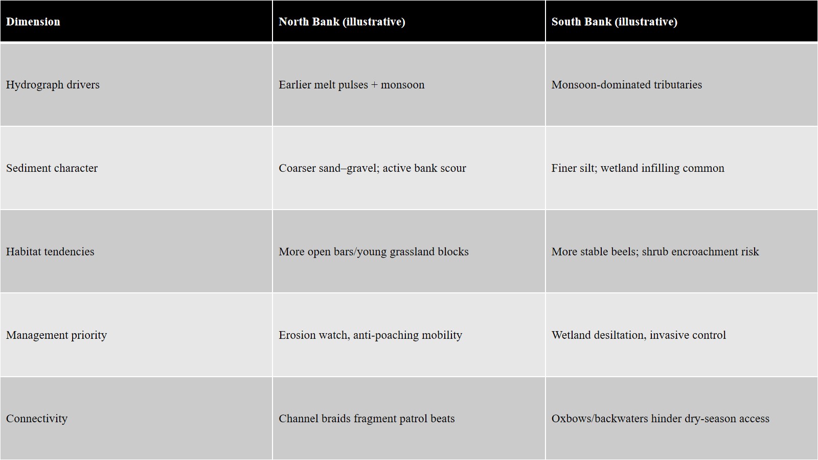
Think of a protected area bounded by a mainstem on one side and a large tributary/secondary branch on the other. The two banks are not mirror images.
Hydrology & sediment
-
North bank (schematic): may receive earlier snowmelt pulses; different tributary timing; relatively coarser load and sharper bank erosion in places.
-
South bank: often gets concentrated monsoon runoff from peninsular slopes/foothills; finer silts may promote wetland infilling and grassland→shrub succession.
-
Confluences near park edges generate bar complexes and backwater effects, altering flood peaks and ponding patterns.
Micro-relief & drainage
-
Alternating levees, swales, and abandoned channels (“beels/oxbow-like wetlands”) create a mosaic: wet meadows, tall-grass blocks, seasonal marsh, riverine forest strips.
Connectivity & patrol logistics
-
Active channels can fragment habitat and disrupt patrol routes. Seasonal sandbar fords, ferry ghats, or temporary bridges are critical for cross-bank movement—by wildlife, forest staff, and sometimes poachers.
Boundary dynamics
-
Legal PA boundaries are often drafted along “right bank/left bank” lines; bankline migration and avulsions can shift reality on the ground, complicating demarcation, settlements, and encroachment cases.
Floodplain ecology inside braided systems
Succession pathway
-
Pioneer sandbar grasses (Saccharum/Imperata) stabilize bars → tall alluvial grasslands → shrub thickets → riverine woodland if floods are muted.
-
Regular floods and occasional controlled burns (where allowed) maintain grassland structure and fauna adapted to open habitats.
Wetlands (“beels”)
-
Cut-off channels and backswamps serve as fish nurseries, amphibian/reptile habitat, and dry-season water for ungulates and birds.
Flagship/indicator fauna (conceptual)
-
A grassland bustard/babbler as floodplain-grass indicator; a hog deer/antelope for tall-grass dependence; a megaherbivore shaping vegetation; river dolphins/crocodilians tied to channel morphology.
Invasive plants
-
Fast-growing vines and herbs can smother grasslands and wetland edges; management mixes mechanical removal, seasonal fire, targeted biocontrol, and community vigilance.
People in the charlands: human geography and trade-offs
-
Char settlements track shifting land; titles are fluid, service delivery is difficult, and disaster exposure is high.
-
Fisheries and seasonal grazing use the same bars that conservation seeks to keep undisturbed.
-
Solutions tested elsewhere: co-management committees, regulated seasonal access, and livelihood diversification (fish processing, eco-guiding).
Disaster risk and river management
-
Flood typology: monsoon peaks; compound events (rain-on-snow); backwater flooding at confluences; flashy tributaries from the hills.
-
Bank-erosion control: spurs, porcupines, revetments vs. setback embankments and room-for-the-river approaches; trade-offs for habitat.
-
Preparedness: gauge telemetry, char-wise siren/PA networks, evacuation routes to high bars, and relief boat staging along both banks.
Conservation governance in a moving landscape
-
PA layering: National Park/WLS/Tiger Reserve; Eco-Sensitive Zones that can flexibly buffer shifting channels.
-
Corridors across water: identify seasonal crossing sites used by elephants/ungulates; avoid fencing that blocks flood escape routes.
-
Relocation & rights: forest village relocation norms; customary fishing/grazing rights; compensation frameworks for erosion-induced displacement.
-
Inter-division coordination: joint patrols and intelligence sharing across districts/states flanking each bank; flood-season command protocols.
Tools & methods (S&T applied to geography/ecology)
-
Remote sensing/GIS: multi-temporal Landsat/Sentinel for bankline migration, bar/island area change, LULC; NDVI to track vegetation stabilization.
-
Hydraulic/planform metrics (conceptual): braiding index, specific stream power to infer likely erosion zones.
-
Field techniques: RTK-GPS shoreline surveys; rapid habitat assessment sheets aligned to floodplain types; community-reported erosion lines geotagging.


